All About Altitude
Instruments greet us from all angles as we step into the flight deck. Amongst them all, you'll find an array of altimeters: Absolutely crucial to aviation for their altitude-sensing capability; but all are not made equal, with different altimeters playing different roles in orchestrating a safe flight.
Although all the different altimeter gauges were laid bare in the flight decks of yesteryear, they're less noticeable in the glass cockpits presently dominant, characterised by large digital screens. The systems are all still there, though.
So, altimeters. What do they all do, and how are they different from each other?
Barometric Altimeters
The barometric altimeter is the most ubiquitous. Baro for short. Let me present a massive simplification: It measures the difference in the air pressure outside, and te air pressure selected by the pilot — you might know that as the QNH.
Since Earth's atmosphere gets thinner with altitude, i.e. air pressure decreases as you climb higher, we can get a good indication of aircraft altitude in this way.
To illustrate: The QNH at Donlon Airport is 1006 hPa. Our aircraft sensors detect a pressure of 906 hPa. We know that, in a standard atmosphere, a displacement of one foot is equal to ~ thirty hPa. Therefore, our barometric altimeter ought to read ~ 3,000 feet.
This is a decent indication, though it gets less reliable the further away from sea level we are; which is why vertical separation minima increase with altitude — particularly above 41,000 feet, the ceiling of what's known as the Reduced Vertical Separation Minima, or RVSM, band.
Airline pilots aren't (usually) adjusting their barometric altimeters throughout the flight, though. Once climbing above the pocket of airspace known as the transition layer, standard pressure is used (ISA). We use the term Flight Level to refer to altitudes relative to standard pressure — FL330, for example, is effectively shorthand for 33,000 feet of altitude above the standard pressure datum.
Heights, Not Altitudes
While QNH is a question of the sea-level pressure over the aerodrome, QFE refers to the pressure observed at aerodrome elevation. Therefore, just as we can measure our altitude over sea level with a barometric altimeter set to QNH, we can also measure our height over aerodrome elevation with a barometric altimeter set to QFE.
This is especially useful for VFR aircraft remaining in the traffic circuit, especially if there's a meaningful difference between sea level and aerodrome elevation. In the circuit, we're flying at much lower levels than other aircraft in the sky, so it might make more sense for 1,000 feet, on QFE, to be our circuit height; rather than 2,300 feet on QNH.
In Russia and other parts of the Former Soviet Union, QFE remains preferred over QNH, and not just for local VFR flights. Even more helpfully, these regions usually express QFE in mmHg, not hPa; even though they'll use hPa if they give you the QNH.
Russia in particular is still undergoing a QFE/mmHg to QNH/hPa transition that started in 2017, and continues to make its way eastward through the country.
Radio Altimeter
Put crudely, the radio altimeter shoots a radio beam towards the ground and measures what reflects back. So long as the ground is below us, and not too far away, it'll give us a good indication of physical height over terrain. It’s mostly used at lower heights, such as on approach, and interacts with the Ground Proximity Warning System (GPWS).
Notice how I said over terrain, and not over the airport. Radio altimeters can't reliably tell you how far you are from touchdown, because Earth isn't flat. But we'll get to that shortly.
One common misconception amongst flight simmers is that, when it comes to IFR approach minima, “baro = MDA” and “radio = MDH”. Really, both of these are barometric minima.
IFR approach minima are often published with both an altitude (MDA/DA) and height (MDH/DH). It's a common misconception amongst flight simmers that baro = MDA, or radio = DH. Really, these are both barometric minima, and shouldn't necessarily rely on the Radio Altimeter.
Procedures intended for Radio Altimeter use should have a specific minima marked RA. If you’re wondering why not to use RA otherwise, let me illustrate by expanding on the Earth Isn't Flat claim I made earlier:
Imagine the runway is situated off the edge of a cliff. The RA may indicate 2000 feet or more, until crossing the runway threshold, when the RA indication suddenly jumps all the way down to just 100 feet. The radio altimeter ‘cares’ only about the physical height over the terrain directly below, which changes as drastically as the terrain does.
Most approaches aren’t situated on a cliff’s edge, but the example should prove illustrative.
Metric Altimeter
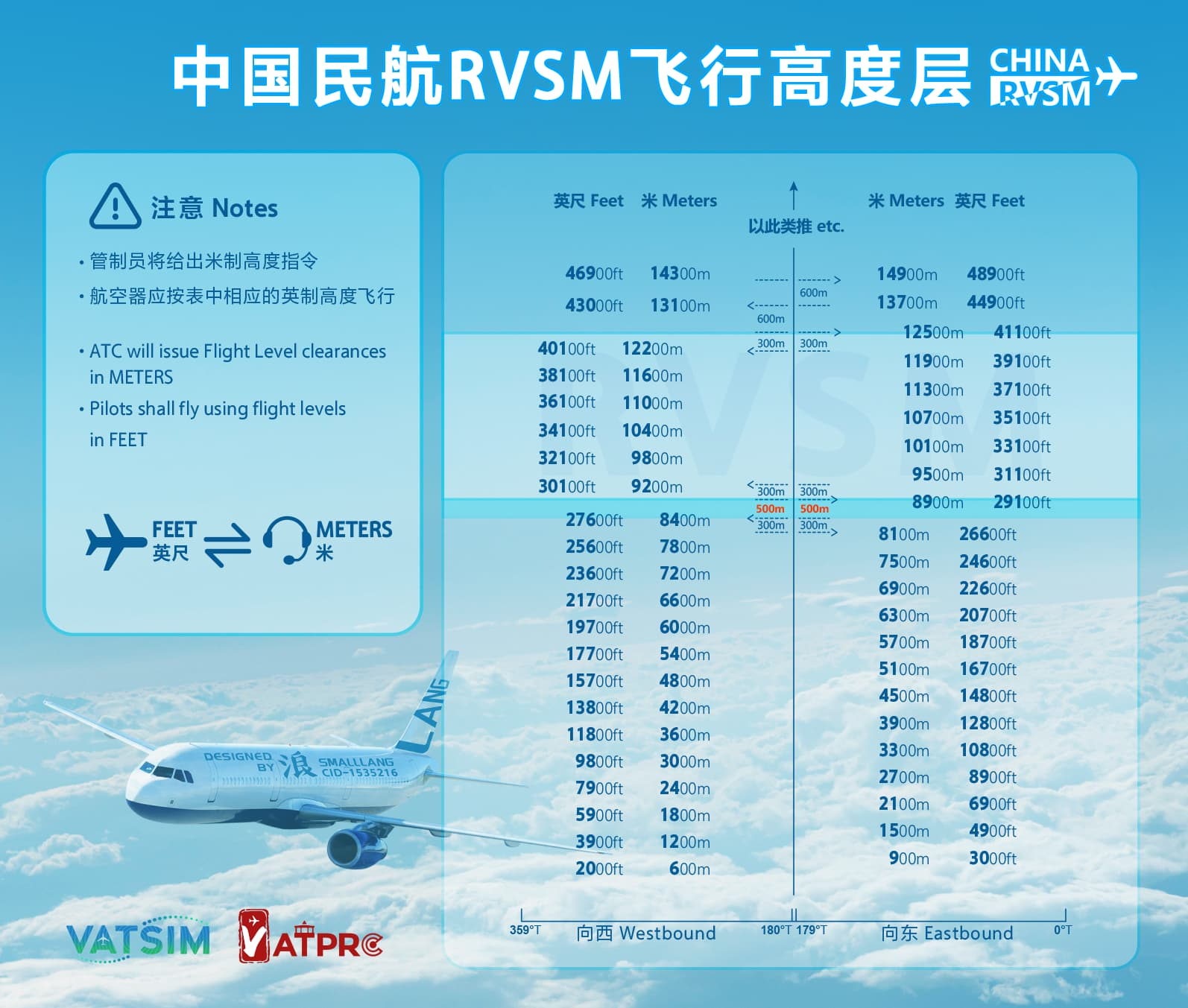
Altitudes are always expressed in feet, right? No. Time for an exception!
China is the most prominent ‘metric club’ member, the handful of places that prefer expressing altitudes with metres rather than feet.
Present-day Boeings and Airbuses can toggle metric indications on/off, which translates the ‘footric’ altitudes into metres; for both the selected altitude, and the barometric altimeter. Nonetheless, standard practice is to cross-reference with a conversion chart, like the image above.
Older aircraft may instead be fitted with a standalone metric altimeter — even on some western aircraft, like the Airbus A300.
P.S.: I’ve dubbed non-metric altimetry as ‘footric’. It hasn’t caught on yet, but that won’t stop me.
Standby Altimeter

The Standby Altimeter has simple life. It's a backup barometric altimeter.
The redundancy proves especially useful if there’s a discrepancy between either the left- or right-side primary altimeter indication.
GPS / GNSS / Satellite Magic
Satellite navigation systems do have the capability to measure height/altitude, but their role is less significant on the flight deck than the other systems we've discussed here. GNSS-based altitude detection isn't used in any ATC procedures (that I'm aware of), isn't assigned by ATC, and isn't be used for maintaining level flight.
Some flight trackers and ADS-B sites do show all the different altitude indications available for an aircraft — including GNSS altitude.
Conclusions
Aviation is a deep, complex, and fascinating topic; even in aspects you might initially dismiss as trivial. Altitude seems like such a given, until it isn't.
Never stop learning!
NB: In the United States, 'altimeter (setting)' is used with the same meaning as 'QNH'. Notwithstanding, QNH is not a unit of measure; QNH is expressed in hPa, inHg, mmHg, etc. 'Altimeter setting' is commonly found in regulatory material the world over, but is typically not found in standard phraseology, except in the United States.
